For the preservation, protection, and maintenance of Lake St. Catherine |
 |
The Lake St. Catherine Stormwater Master Plan
WHAT IS STORMWATER RUNOFF?
Stormwater runoff is generated any time rain or melting snow/ice runs off the land; stormwater runoff typically increases when the land use has been altered from its natural state. Typically, hardened surfaces such as rooftops and roads are the primary sources of stormwater runoff, however in a rural setting it is important to consider hayfields, pasture, and other developed or agricultural areas that may increase and concentrate runoff. Increased stormwater runoff leads to higher magnitude flood flows and greater erosive power in stream channels, increased delivery of sediment, nutrients, and other pollutants to waterways, and increased flooding conflicts with improved properties downstream. The network of roads, ditches, and culverts that are found in steep, rural settings are important for conveying stormwater and protecting infrastructure. However, these systems concentrate runoff, reduce infiltration, and may lead to areas of erosion and sediment generation. Increased stormwater runoff is directly linked to the quality of water in the streams, rivers, ponds, and lakes that we depend on for drinking water, healthy fisheries, and recreation.
WHAT IS A STORMWATER MASTER PLAN?
 The stormwater master planning process is used to identify current stormwater inputs to surface waters. The relative impact from each of these inputs is calculated and the ranked projects can then be prioritized with feedback from local stakeholders who are familiar with both the storm-related problems and the capacity and resources available to assist in their mitigation. The Wells Brook / Lake St. Catherine Stormwater Master Plan was developed with public involvement and comment and is as comprehensive as possible in listing all known problems. The plan is based on a prioritized list of projects and a strategic approach and is potentially more likely to succeed than a reactionary approach that addresses problems as they arise.
WHAT IS THE GOAL OF A STORMWATER MASTER PLAN?
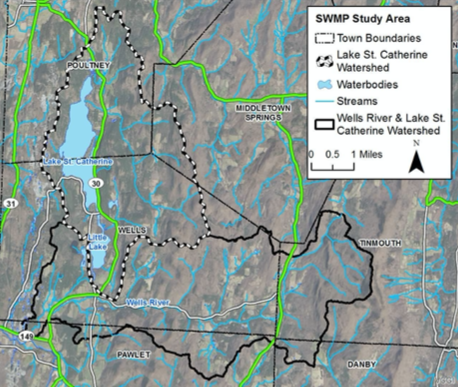
The goal of this project was to evaluate approximately 20,871 acres (32.6 mi^2) within the Wells Brook Watershed (a subwatershed within the Mettowee River / Wells Brook USGS HUC12) with a specific focus on the 9,050 acres within the Lake St. Catherine watershed to identify sources of increased stormwater runoff and associated sediments and nutrients. Phosphorus reducing projects are of particular importance given the water quality concerns within the watershed. The work involved identifying sources of stormwater, prioritizing sources based on various environmental, economic, and social criteria, and designing projects to mitigate those sources.
Stormwater mitigation projects are aimed at reducing or eliminating stormwater at the source through Green Stormwater Infrastructure (GSI) approaches (constructed features that use living systems to provide environmental services), retrofits of older and underperforming stormwater features, back road erosion projects, and improving floodplain access within the river corridor to increase sediment and nutrient attenuation. In addition to traditional stormwater projects, the SWMP attempted to identify projects at the shoreline parcel scale and included Lake Wise Assessments, which promote increased natural buffers and decreased impervious surfaces, might positively impact water quality.
WHO IS WORKING ON THE LAKE ST. CATHERINE STORMWATER MASTER PLAN?
In 2017 the Poultney Mettowee Natural Resources Conservation District (PMNRCD) received grant funding from the Vermont Agency of Natural Resources (VTANR) Ecosystem Restoration Program to carry out stormwater master planning and Lake Wise assessment efforts in the Wells River/ Lake St. Catherine watershed. PMNRCD hired Fitzgerald Environmental Associates (FEA) in the fall of 2017 to assist with the development of the Stormwater Master Plan (SWMP) for the watershed. The SWMP follows the VTANR SWMP guidelines and was developed over the course of 2018 and 2019 through extensive field work, interaction with multiple stakeholders within the study area to prioritize projects, and follow-up analysis and design work. The LSCA is working closely with the PMNRCD on this effort.
WHERE ARE THE AREAS OF CONCERN IDENTIFIED BY THE STORMWATER MASTERPLAN?
50 locations were identified in the initial assessment, and as of this writing, and 6 projects have moved ahead.
Below is a map of the Stormwater Master Plan locations. Orange check icons indicate a completed project, green construction icons indicate a project that has been designed and implementation is underway or about to begin, and yellow dot icons indicate potential future project locations. Use the + / - on the map to zoom in and out. Click on an icon to see a description of the issue, the proposed intervention, and a photo of the area.
If you are aware of a stormwater runoff location on the lake that is not identified here, please contact us at info@lakestcatherine.org.
ADDITIONAL RESOURCES
All of the Lake St. Catherine Stormwater Master Plan documents can be viewed by clicking here, including the project designs that were presented at the Stormwater Master Plan meeting on June 25th, 2025, and you can view that here:
