For the preservation, protection, and maintenance of Lake St. Catherine |
 |
Water And Shoreline Protection
A LAKE'S EDGE
A lake shoreline is an important edge area that connects the aquatic world with the adjacent upland, and sets the stage for swimmable, fishable, and enjoyable water. Native flowering shrubs and trees attract beneficial pollinator species, including bees and butterflies, and adorn the shore with colorful blooms and foliage.
Beds of aquatic plants provide refuge for fish and invertebrates to feed, rest, and reproduce. Overhanging tree limbs provide shady havens for wading birds and fish. Rocks, roots, and half-submerged logs protect the shoreline from wave action, and supply sunny resting spots for turtles. A forest floor of leaves, pine needles, moss, and decaying twigs (referred to as the “duff layer”) acts as a natural sponge and soaks up rain and stormwater runoff.
A healthy, natural lake shoreline is a diverse and intricate place. Clearing native vegetation, converting the forest duff layer to a lawn, or pouring a new house foundation are all activities that remove a lakeshore’s natural capacity to sustain wildlife and handle flood events. Resisting the urge to tidy up a “messy” shoreline will support a storm-resilient property and help contribute to a more vibrant lake overall.
WHO OWNS THE WATER?
Public lakes and ponds belong to the people of Vermont - they are managed in a manner which preserves and protects a healthy ecosystem as well as guarantees the right for all to swim, fish, boat, and otherwise enjoy. This concept is referred to as Vermont's Public Trust Doctrine.
Lakeshore property in Vermont extends down to the mean (average) water level. Beyond mean water level, the water and lakebottom are public resources to be shared, much like space is shared at a public park.
Projects that propose work beyond mean water level may require a Lake Encroachment Permit. Encroachment projects include, but are not limited to, the installation of a shoreline stabilization project, repairs to an existing boathouse, or additions or removal of fill. Projects are reviewed to ensure the encroachment is as minimal as possible, that all other less intrusive options have been considered, and that the project is consistent with the Public Trust Doctrine.
SHORELAND DEVELOPMENT
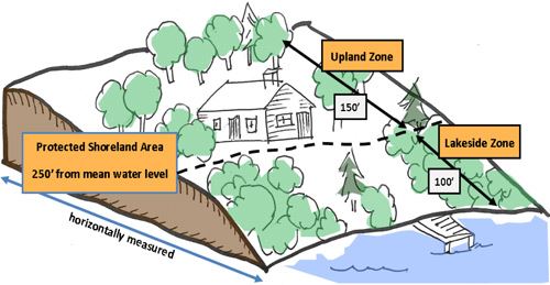
 Landowners looking to develop lakeshore property will need to understand Vermont’s Shoreland Protection Act. Under the Act, a Shoreland Protection Permit or Registration is needed to create new cleared area or new impervious surface within 250 feet of mean water level of a lake 10 acres or larger.
An impervious surface is any solid or compacted surface where stormwater runs off instead of infiltrating - this includes houses, garages, decks, parking areas, and both paved and unpaved driveways. As stormwater runs across a solid surface, it picks up sediment, oil, road salt, and other pollutants, and carries them lakeward.
Removing trees, shrubs, groundcover, or the natural forest duff layer is considered creating cleared area. Regularly maintained lawns, landscaped areas, and impervious surfaces are all cleared areas.
The Act requires new development to be set at least 100 feet back from mean water level. Expansions of existing development are permitted to the back or side, but not closer towards the lake. All projects within the protected shoreland area must follow these additional development standards:
- Avoid steep, unstable grades: keep projects in areas with a slope less than 20%.
- Minimize development: no more than 20% of the parcel should be impervious surface.
- Keep natural vegetative cover: no more than 40% of the parcel should be cleared.
The Act's Vegetation Protection Standards allows lakeshore landowners to selectively remove individual trees in a manner that allows for lake views and light, while still preserving the benefits of a forested shoreland.
SHORELAND STABILIZATION
Waves, ice push, and upland runoff can contribute to erosion at the shoreline, especially at those areas devoid of vegetation. Minimizing "lawn-to-lake" landscaping and creating a no-mow zone along the shoreline is a simple approach to tackling erosion. For landowners who don't mind a little sweat equity, actively planting trees and shrubs can further enhance stability at the shore.
In more heavily eroded areas, bioengineering methods that use biodegradable materials, dry-laid stone, and native plants are encouraged. Mimicking a natural shoreline requires minimal long-term maintenance, provides important habitat, and is aesthetically pleasing for those viewing from land or water.
Solid, vertical retaining walls along the shoreline create an artificial barrier between land and water. Retaining walls are mistakenly perceived to be more stable – in reality, waves crashing into the retaining wall will bounce back, causing scouring around and under the edges of the wall. For these reasons, vertical retaining walls are not recommended and new walls are generally not approved.
Shoreline stabilization projects extending below mean water level will require a Lake Encroachment Permit. Occasionally, stabilization projects will need both a Shoreland Protection and Encroachment permit.
OTHER DEVELOPMENT CONSIDERATIONS
The Department of Environmental Conservation's Assistance Office can help identify any other permits that may be needed for your project, including:
Wetlands
In addition to supporting unique plants and wildlife, wetlands provide major flood carrying capacity, which could protect your home during a storm event. Vermont protects wetlands that hold significant ecological value, and development within a protected wetland or its surrounding buffer requires review by the DEC's Wetlands Program.
Wastewater/Water Supply
Proper installation and maintenance of your wastewater / septic system is crucial to keeping nutrients and pathogenic bacteria from the lake. Adding more bedrooms to a home or converting a summer camp to a year-round residence? Your project should be reviewed by the DEC's Drinking Water and Groundwater Division.
Acquiring state permits does not relieve a landowner from complying with municipal and federal regulations. Local zoning varies across Vermont, so be sure to contact the zoning administrator or town clerk. The United States Army Corps of Engineers (USACE) may require notification if you intend to work within certain waters or wetlands.
Lastly, consider consulting a professional who has attended the DEC's Natural Shoreland Erosion Control Certification course. In addition to knowing construction practices that are protective of water quality, they will be familiar with bioengineering techniques and permitting requirements.
AQUATIC PLANTS
Often disregarded as "weeds," aquatic plants are incredibly important parts of a lake ecosystem. Through photosynthesis, aquatic plants produce oxygen for the lake. They take up nutrients such as phosphorus that would otherwise fuel algal blooms. Rooted aquatic vegetation holds lake bottom sediment in place and keeps water clear. Beds of aquatic plants provide refuge for fish and birds to feed and nest.
Occasionally, some aquatic plant control may be desired in order to maintain a public swimming area, manage an invasive species, or improve boat navigation. The Lakes & Ponds Program provides guidance on plant management options. Aquatic plants can be removed by hand, but use of powered mechanical equipment, bottom barriers, or herbicides will require an Aquatic Nuisance Control Permit.
Excessive removal of aquatic plants may result in increased erosion and murky water. As spawning habitat disappears, you may notice fewer fish. Algal blooms may become frequent as phosphorus becomes more freely available.
- Adapted from the Vermont DEC's "Sharing The Edge - A Guide For Lakeshore Property Owners In Vermont"
WATER QUALITY & LAY MONITORING AT LAKE ST. CATHERINE
The Lakes & Ponds Program has been monitoring the water quality of Lake Champlain and Vermont’s inland lakes and ponds since the 1970’s. Every spring following ice out, the Program's biologists suit up and head out to measure how much phosphorus is available to fuel algae and aquatic plant growth throughout the year. Later in the summer, they collect information on lake and shoreline habitat and sample for other water quality parameters.
The Vermont Inland Lake Score Card is a user-friendly visual resource available as a layer on Google Earth. A simple color-coded icon indicates how a lake scores for nutrient amount, habitat, mercury pollution, and invasive species presence. Links embedded within the Score Card allow an interested viewer to dive deeper into the data (see Score Cards below).
The LSCA participates in the Vermont DEC's Lay Monitoring Program. LSCA Trustee and Water Quality Chair Mary Jo Teetor collects weekly water samples from Big Lake and Little Lake from Memorial Day to Labor Day each season. These samples are sent to the DEC for testing. The water is tested for phosphorus, clarity (secchi depth), and chlorophyll-a (algae). You can review the data from the Big Lake (since 1979) and Little Lake (since 2009) by visiting the Lay Monitoring Lake Water Quality Data website. When on this page, select 'Wells' from the 'Select Town' dropdown, and Big Lake and Little Lake data will be available to view.
VERMONT INLAND LAKE SCORE CARD
LILY POND
View Detailed Nutrient Trends and Status View Plant List, Including Invasive Plants |
BIG LAKE
View Detailed Nutrient Trends and Status View Plant List, Including Invasive Plants |
||||||||
LITTLE LAKE
View Detailed Nutrient Trends and Status View Plant List, Including Invasive Plants |
SCORING SYSTEM
How lakes are scored / How to maintain or improve a lake's score
|

